I wanted to explore this neighborhood that is often written off as dull by most observers and so over a couple days, I hopped on and off the DASH mini-buses that run on a loop around the area every 15 minutes
(and walked in the areas not along the route). I took photos of various places as well as trying to dig deep for information and develop a liberating perspective.
A brief primer on Northridge and some of its features: (If this kind of stuff bores you and you would just like to read narrative with some photos and commentary, you can scroll down to where it says
START HERE)
Northridge- a community in the northwestern portion of the San Fernando Valley and home to just over 60,000 people (as of the 2010 Census). Originally known as Totongna to Native Americans in the area (most of whom were lost to the painful Spanish missionary process that began in the late 18th century), it was re-founded as Zelzah in 1911 (renamed North Los Angeles in 1929 and Northridge in 1938) and is now part of the City of Los Angeles, but like many annexed portions of the city, still writes its community name in addresses ("Northridge, CA" instead of "Los Angeles, CA"). Ethnically it is 40% white, 34% Latino, 17% Asian, and 5% black. It is the location of California State University- Northridge (CSUN) and associated with a major 1994 earthquake that had its epicenter in neighboring Reseda. One of the oldest buildings is the Faith Bible Church from 1917 which is now a Korean church and senior center.
 |
| Faith Bible Church as seen from Reseda Boulevard, north of Parthenia |
Surrounding it is the main north-south artery, Reseda Boulevard, which featured the main commercial core of Northridge until the Northridge Fashion Center shopping mall opened in 1971, shifting the focus away.
CSUN- Cal State Northridge was founded in 1958 as "San Fernando Valley State College".
 |
| The library at CSUN. It was Starfleet Academy in the 2009 Star Trek film. |
The administration office was dramatically seized in 1968 by students demanding more diversity in the student enrollment and faculty and the formation of Pan-African Studies and similar departments. Throughout that year and 1969, CSUN was a major site of student-lead protest against racism, war, and similar issues of the day. Today it has the largest Chican@ studies program of any university, the first Central American Studies department, the National Center on Deafness, and similar coursework. The school is also
one of the largest sites for sustainability (by the way these yellow boxes, except for the start here ones, are links) including the only university to have energy from an on-site hydrogen fuel cell. 13% of the enrollment of 30,000 is an international student and most of the overall student body is Latino, Asian, Middle Eastern, or African-American.
 |
| Reflecting this, popular local (Southern California and Las Vegas) taco entrepreneurs, Rigo's Tacos opened their 9th location, this time in Northridge and offering CSUN student discounts. |
 |
| The tallest building, known as "West Valley Corporate Center" above senior citizen assisted living and one of the last remaining large vacant parcels in the area. |
West Valley Corporate Center and state enterprise zone- overlapping between Chatsworth and Northridge, this former industrial area has seen government subsidies to medium and large businesses. As a result of this process, the area has seen the construction of a multi-building office campus that is home to various organizations including the local Department of Homeland Security offices and Chase Bank. The tallest building is a 10-story building dating from 1992. The offices for City Council District 12 (the Northwest Valley) are located in this business complex also.
 |
| Bryant Street gang tagging in December 2012 on Tampa Avenue at Parthenia |
Bryant-Vanalden- a low-income area within Northridge
that was built in the mid 1960s and has faced numerous efforts to handle
crime. Though still frequently tagged by the local gang, it is a lot
safer than it was in the 1980s and 1990s.

Sherwood Forest- Throughout Los Angeles (and in particular the San Fernando Valley), it is customary for segments of neighborhoods to periodically "secede" from each other, in particular for property value reasons since the neighborhoods have postal designation status and therefore being "Arleta, CA" can command higher housing prices than "Pacoima, CA". This can be seen with the 1987 renaming of a portion of Canoga Park as "West Hills", the 1992 rebranding of Sepulveda into "North Hills", the renaming of "Lake Balboa" from a portion of Van Nuys, "Valley Village" from North Hollywood (and in that case "Noho Arts District" to differentiate the gentrified area near the Metro station from the largely working class Latino area to the north), and so on. This year, signs went up near Cal State Northridge declaring that particular area southeast of CSUN to now be "Sherwood Forest". The northern portion of Northridge had long ago referred to itself as "Porter Ranch" and the line of areas considered Porter Ranch has dropped down to Devonshire street. The area considered "Northridge" has been further reduced. Is this indicative of how people feel about Northridge? Is it a place now largely defined by a catastrophic earthquake, CSUN, a mall, and aging areas like Byrant-Vanalden? The fact that the homeowners in "Sherwood Forest" named their neighborhood after a forest in England associated with the legend of Robin Hood can speak for itself.
 |
| "pc.Bst.13" (Panorama City Blythe Street mexican mafia) crossed out by "Vincent Town" from North Hills (some of their tags have "13" also indicating mexican mafia) |
Contested Alley- Over a period of two years, I have documented walls in and around an alleyway south of Roscoe that are constantly tagged by different gangs of the Valley. This particular area is not specifically part of a gang's claimed territory, but it always is tagged by different gangs so there is another reason. I have seen drug-money exchanges take place here and so I suppose each gang wants to claim the lucrative spot. A couple times I've seen very expensive cars "drive-thru" as their presumably rich occupants purchase from a youth on a bicycle. That's just a symptom of capitalism I suppose and
also, governments do this on a national scale . In fact it might just be an example of humanity, even if it is one we don't like to acknowledge. And to this, advertisements, billboards and signs are all this to me. If one would be critical of the gang tagging, one must be critical of the flags of nations that rise over the battlefields of the planet
 |
| Girl plays on missile on display at Fort MacArthur in San Pedro | , July 2012 | | | | |
|
|
And also for this:
 |
| people camp out on Thanksgiving night 2012 to be first into the store to buy | |
|
|
So far there has been no violence at this spot, just the constant crossing out of other gang tags and the constant repainting of the entire wall by the homeowner. I am by no means defending gangs, merely acknowledging that they are part of larger systems, not apart from them. This specific wall has many implications if one "reads" it fully.
START HERE
I began at Corbin and Parthenia where I and a couple Jehova's Witnesses who were going door to door were the only pedestrians on our side of the street.
Across the street was a fresh fruit vendor. An indicator of social capital, in my opinion. Street interaction is rarely observed around here, but this frutas stand is always here, as is one closer to Northridge mall and one by CSUN.
Continuing on I walked over the railroad tracks.
Is there a "wrong" side? Perhaps further along but I'll get to that. On the bridge over the railway, I spied the 10-story West Valley Corporate Center of the state enterprise zone
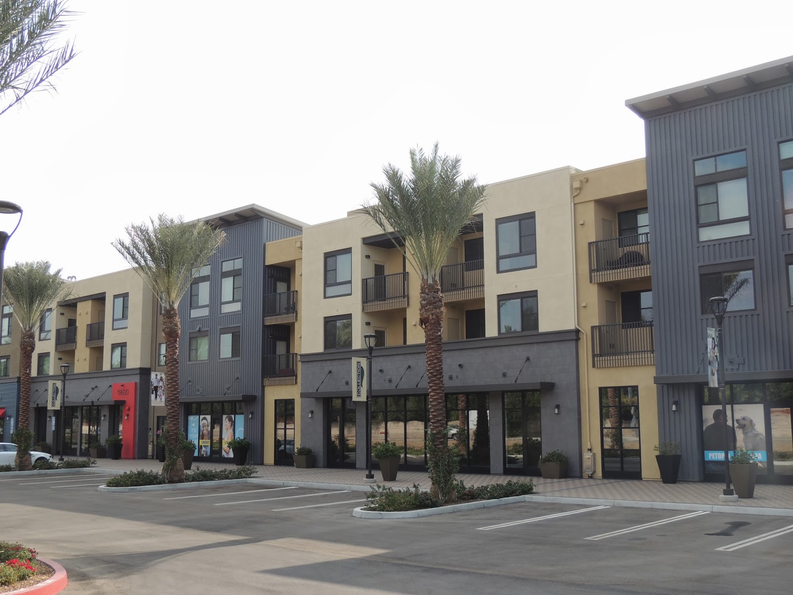
Walking over toward it, a few things caught my eye. The first was an alleyway that was a short cut between the mall and what used to be a Kmart. Up ahead, the one story Kmart with its very large surface parking lot had been replaced by a new multi-story building that is apartments above (still vacant) retail spaces.
This apartment complex also has its own "farm" (a community food
garden). I feel as long as these kinds of developments maintain a
certain level of accessibility to low and middle income earners, they
are a healthy vision for future suburbanism.
Across the street to the north, the neighborhood hides behind walls and turns its back on the street and its emergent vitality potential.
Across from the apartment complex is the actual clear delineation of space marking the state enterprise zone. Here, low slung minimalist office buildings 2-3 floors (along with the outlier 10 story corporate center) are among disused railway spurs from when this was a light industrial and warehouse hub off of the main railroad line. Local municipal government offices are here as Los Angeles County facilities and even federal level in the form of Department of Homeland Security citizenship and immigration offices.
This was the only person I saw out and about in this office complex.
Even the state enterprise zone is not immune from the crafty storage of a discarded shopping cart above the flood control canal.
In this barren landscape, I saw an "encampment" in the doorway of an empty office building. This sign of human life was so surreal in that moment. It was like I was looking into the far future past the point of the current paradigm's collapse, as the remnants of humanity took shelter in structures that had no other purpose. In different context, perhaps in let's say humanity's past, these urban nomads and foragers would be seen in different lights. Perhaps as ascetics, wise people, journeymen, etc who had willingly chose to live a non-domesticated life in order to gain alternative perspectives and were recognized as such. Today they are looked through, looked past, or looked down on. We see them as failures, mentally ill, drug addicted, etc. or even as "victims" who have sled through the slippery cracks of normalcy's floorboards. The cult of
Diogenes lives on, at least to me.
 |
| Buddhist monk in Japan with begging bowl |
At least some employees commute via vanpool.
And this Metrolink truck outfitted to run on rails checks the rail line.
Having felt satisfied with my exploration of the state enterprise zone, I re-boarded a DASH shuttle bus and looped around to my next zone of focus, the Bryant-Vanalden area.
 |
| a "welcome to Bryant Street" tag |
|
The area was established in the mid 1960's as part of President Johnson's "War on Poverty". It concentrated low-income people in many large apartment buildings south of the industrial area around the railroad tracks near Parthenia and Wilbur streets. By the late 1970s it was a large open air market for drugs and prostitution and the violence of competing gangs over these lucrative monetary opportunities.
 |
| A wall in the area in 1981 (image from Los Angeles Public Library's photo collection) |
The city responded by approving a plan in 1985 to mass evict the 3,000 or so residents (it was hard to keep track of the people living there at any given time) and building middle-income market rate housing with the former residents who qualified as official lease holders, expected to take a small lump resettlement payment and find somewhere else to go.
 |
| 1985 photo of anti-eviction rally (Los Angeles Public Library photo collection) | | | |
|
|
|
Instead, most of the buildings were seized by the city from various "slum-lord" land lords and sold en mass to a developer from India who renamed it "Park Parthenia", gated it, re-painted it, and had one vehicular way in and out with a checkpoint manned by guards in bulletproof vests.
Crime has decreased (though crime throughout the United States has in general fallen for
various reasons ) and though the tactics have created a very unusual environment.
Though many would look down on Bryant-Vanaldan, I do not. I still feel that life and humanity is thriving here. And at fear of being perceived as an insensitive interloper who peddles
ruin porn, I almost didn't post my photographs. But as I have neither an agenda to spit on someone's home, nor celebrate certain aspects, I am simply capturing
what is, the same way I observe anywhere else. In fact Bryant-Vanalden seems less depressing to me than the state enterprise zone. It is more alive. Hope is tangible in the air. I feel it. Humanity is alive and on display. Extra-terrestrials come forth and see us.
For example, the photo above this shows what is essentially a seven-day-a-week garage sale run by professional "salvageers" not unlike what is common throughout the world. Free market capitalism.
And there are many vendors selling chips, ice cream, raspados (flavored shaved ice), drinks, etc.
In fact there is an elementary school (Napa Street School, among the many schools my mother taught at) and many of the residents of this community are families.
Looking closely at windows reveals a brief vision of the inhabitant
I went looking for the wall that I had seen in the 1981 photograph from the library. I saw fresh tagging almost all over the neighborhood from the local gang, Bryant Street. Though I did not see anyone who I would imagine to be a member of a gang. But
I was there during the day
I think I found it.
It is important to step back from our subjectivity and be objective from reality. Is this possible?
Do we:
* directly perceive objects outside the mind by the senses?
* only infer the existence of mind-independent realities on the basis that different representative ideas figure in consciousness?
* deny that there are any objects outside of consciousness?
*say that there are no unchanging essential natures and that there can be no complete and correct theories about what there is?
Is there in fact no intrinsic change, only successive replacement?
The sky was caged above the cords of power, but progress lurks just beneath. We do not need to be prayed for, but thanks anyways
 (click on the map to make it bigger) and click yellow boxes (except for the "start here" ones) to go to links. Have fun and my thanks in advance to those who make it all the way through


Nice to know the history around here.My parents would tell me that in the 90s they would see alot of dead bodies on the streets.
ReplyDelete